Climate Chart Kampala – 1,202m / 3,945ft
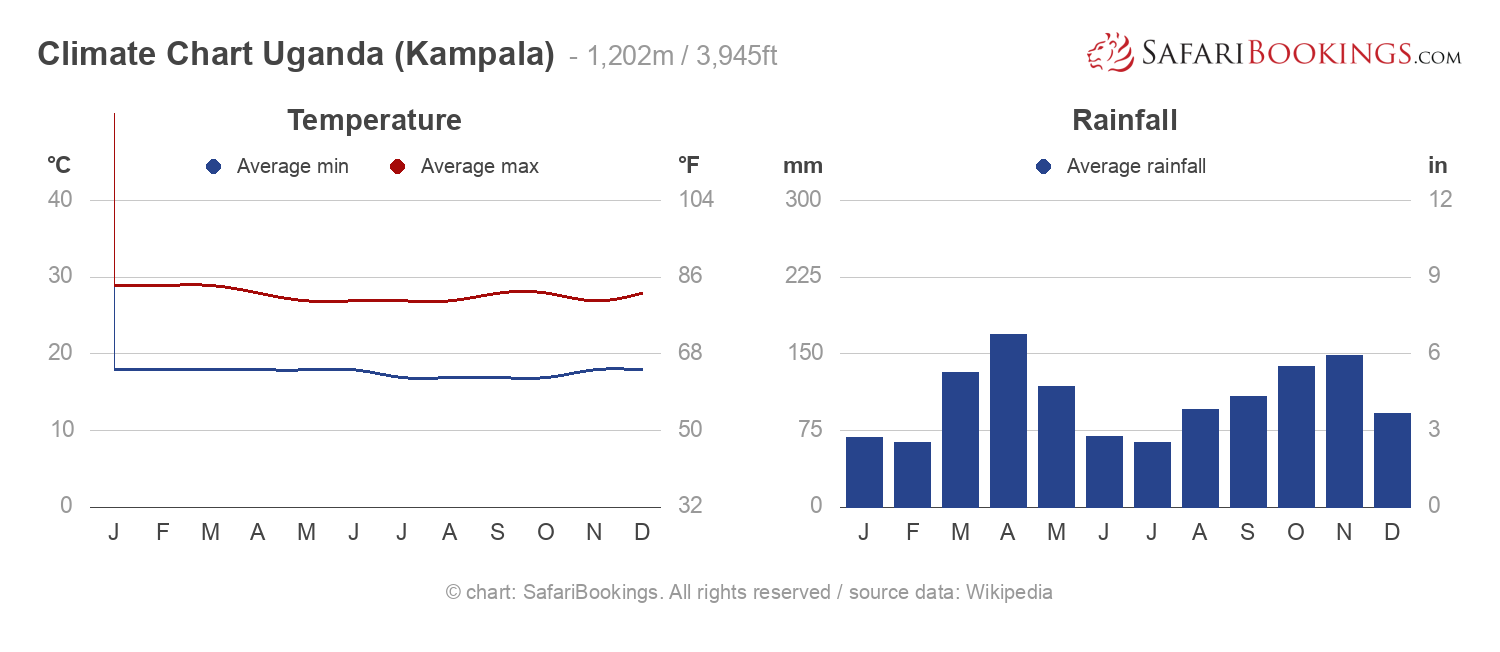
Straddling the equator, Uganda has little year-round variation in temperature. The hottest months are January and February when the average daytime range is 24°C to 33°C (75°F to 91°F) with peaks of up to 40°C/104°F in the far north. The south has two Wet seasons: from September to November and from March to May, but it can rain at any time. The north has one continuous Wet season from March to November and a more obvious Dry season from December to February.
Kampala’s Climate Compared to Uganda’s Parks
For a smallish country, Uganda has considerable regional climate variation, influenced both by altitude and by the local effects of some of Africa’s largest lakes and mountains. For this reason, the Dry and Wet seasons for many parks differ from the national norm. In general, southern and central Uganda have a similar tropical climate to the capital city Kampala. The city has a slightly milder climate due to its location near Lake Victoria. The parks in the south of the country tend to be a bit warmer during the day and cooler at night. The highlands of the southwest (which includes Bwindi Impenetrable and Mgahinga Gorilla National Parks) are considerably colder. In the north, Murchison Falls and Kidepo Valley National Parks are warmer, with daytime temperatures averaging 32°C/90°F.
For a smallish country, Uganda has considerable regional climate variation, influenced both by altitude and by the local effects of some of Africa’s largest lakes and mountains. For this reason, the Dry and Wet seasons for many parks differ from the national norm. In general, southern and central Uganda have a similar tropical climate to the capital city Kampala. The city has a slightly milder climate due to its location near Lake Victoria. The parks in the south of the country tend to be a bit warmer during the day and cooler at night. The highlands of the southwest (which includes Bwindi Impenetrable and Mgahinga Gorilla National Parks) are considerably colder. In the north, Murchison Falls and Kidepo Valley National Parks are warmer, with daytime temperatures averaging 32°C/90°F.
Dry Seasons June to August & December to February
Average temperatures hover around 27°C/81°F in the afternoon and 16°C/61°F in the morning. It will be colder at altitudes above 1,300m/4,265ft, which includes the gorilla parks.
 View Photos
- June, July & August – June and July are the driest months in the south, but it can still rain. Conversely, these months are part of the Wet season in the north. However, the far north, including Kidepo Valley, is semi-arid and can experience droughts some years.
- December, January & February – Most of the south has less rainfall, but there is still more rain than in June and July. The north has a clear Dry season with little rain.
Dry Season Photos
Wet Seasons March to May & September to November
Daytime temperatures average around 28°C/82°F and morning temperatures around 16°C/61°F. It will be colder in the gorilla parks at high altitudes and warmer in the north.
 View Photos
- March, April & May – There is more rainfall throughout the country during these months, with a marked peak in April in the south. Most days have some sunshine as well. The rain can make travel more difficult.
- September, October & November – These months are similar to March, April and May but, on average, there is a bit less rain.


